Your first view of the park is the iconic view of Yosemite Valley. From that height, all you see are trees, granite, and Bridal Veil Falls with El Capital to the right and half Dome in the back. It is truly beautiful and amazing that you do not see one single spec of civilization. Only when you actually enter the valley do you see all the tourists, traffic, shops, etc. Also, it seems like everywhere you turn you can see a waterfall. Due to the lack of the normal snow and rainfall this year, the waterfalls were not as heavy and pretty as we have seen them in the past. (Most of my best pictures are in scrapbooks when I was still using a film camera.) El Capitan is THE icon of Yosemite and the other icon of Yosemite is Half Dome (the 3rd picture). We took the road to the top of it on our 1st visit in 2004. At the very top, the road takes a sharp curve to the parking lot right on the edge of the cliff, no shoulder, & a straight drop down!! You can tell from the picture that is is a LONG way down! I was petrified!! I did not want to drive up there this trip, to the point of deciding that if Doug wanted to go bad enough, I would either wait at the bottom, or ride up lying down in the back seat! That is how scared I am of that road! Whew! Thank goodness we didn’t have time to to go up there!


Our first stop on the way to the valley was up to the Mariposa Grove. The attraction is a moderate hike through the Giant Sequoia trees to the ‘Grizzly Giant’, which is a giant sequoia. It has a volume of 34,005 cubic feet making it the 25th largest giant sequoia living today. The Mariposa Grove was first visited by non-natives in 1857 and named the it after Mariposa County, CA. Mariposa Grove is the largest grove of sequoias in Yosemite National Park, with several hundred mature examples of the tree. Two of its trees, the Washington tree and the Grizzly Giant, are among the largest giant sequoias in the world. Unfortunately, the Giant Grizzly was struck by lightning several years ago, and it took off a top portion of the tree. However, I do have a film picture of the full tree from 2004. You can see the change between the 1st picture and the 2nd one.


We knew we needed to be at the park early, and the evidence was clear when we left the grove. We got to the grove at 9:00 AM and when we left the parking lot at 10:00 AM, the road up to the grove was already closed because all the parking areas were full! This is on a weekday and early in the morning! There was a long line of cars and a ranger was directing the cars to pull over into a lower parking area that was filling up fast. Otherwise, I guess you have to wait in line for a ranger at the top to use their walkie-talkie to call the ranger below to tell him how many spaces had opened up in the upper parking lot. I guess people below had to wait for a shuttle to the hiking area. The park also provides open air trams to take you on a loop through the grove but you don’t get off to visit areas. Boy, we got to the grove in the nick of time! Heading on to the valley, the traffic was bumper to bumper followed by tour bus after tour bus! Because we had been to the park 3 times already, we decided to explore the upper back country. The road out of the valley winds up and around the side of the mountains and through the forest, with parts having drop offs with no shoulders. You would think that after all our travels, I would be used to it by now. NOT!!! I STILL don’t like it! I lean into Doug as far as I can, grip the door handle tightly, look the other way, and breathe heavily! Only makes my hair whiter! The forest is so pretty and green, then at the higher level, you are driving among the granite formations. Patches of snow adds to the beauty.

 The most popular overlook on the back country drive is the Olmsted overlook, which offers a great view of the backside of Half Dome, the peak near the center of the picture. With binoculars, you can see hikers climbing to the top and pulling themselves up the very steep 45 degree incline using chains! Now that takes guts and maybe being just plain crazy! I got dizzy just watching them!
 The same overlook offers a stunning view of more mountains and Tenaya Lake. Love the blue sky, snow, and blue water!
 Then the road took us down to the lake and what a beautiful area! This is where we had lunch and it was another perfect setting with stunning views! Ah..just being outdoors and in a place like this is just fantastic!


We finished our drive at Tuolumne Meadows with panoramic views rising from the lush green meadows. What a great drive to explore the back country! We figured only about 1 in 10 people probably take the time to explore this area. Most of the tourists concentrate all their time in the valley. Just gorgeous up there!


We returned to the valley and I wanted to get a picture of Upper Yosemite falls (#1) and compare it to ta picture I took in 2010 (#2). The 2010 picture is one of my favorites. We did have time to take a short bike ride to the Lower Yosemite Falls, which is at the bottom of the waterfall behind the trees. You can really see the difference in the level of the Merced River due to the drought. The sun was low by the time we reached the Lower Yosemite Falls so the picture is rather dark but still a very popular trail.


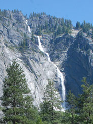
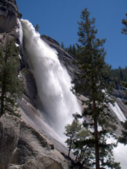
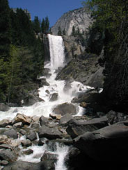
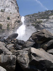
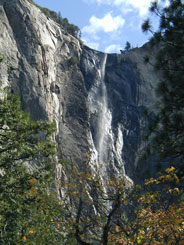
Below are some of the other waterfalls in the valley. Yosemite has the largest concentration of waterfalls in one area. You have to hike to see Vernal and Nevada Falls but well worth it, and we did that in 2004. The others offer a superb sight as you drive through the valley floor. And of course, no matter where you go in the valley, El Capitan is always looming over this wonderful place as you enter and as you leave.



We took the time to revisit Yosemite because we were so close by and don’t know if we will be this way again. Gosh…just give me snow topped mountain views, waterfalls, blue skies, and I am happy………..
Such gorgeous countryside. I love waterfalls. The drought is hitting hard everywhere out here in the southwest. I can usually most mountain roads but I have to admit, going up to Pike's Peak there were a couple of times when I leaned over towards Jim.
ReplyDelete